 |
 |
The problem of forest fires is a major issue in the Mediterranean region. Rainfall occurring shortly after a fire can cause significant damage in terms of runoff volumes and material transport. In recent years, regional increases in temperature, aridity and drought have increased the frequency and intensity of fires, with a spatial extension beyond the regions previously commonly affected. The phenomena of runoff and soil erosion after a fire are not well known and decision-makers wish to identify the most effective actions to be implemented after fires.
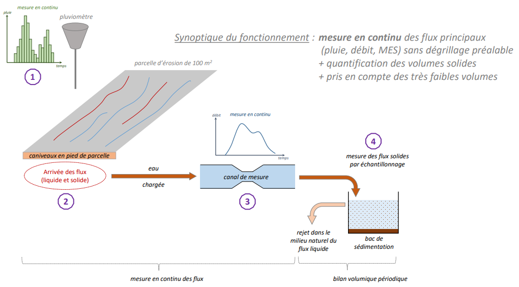
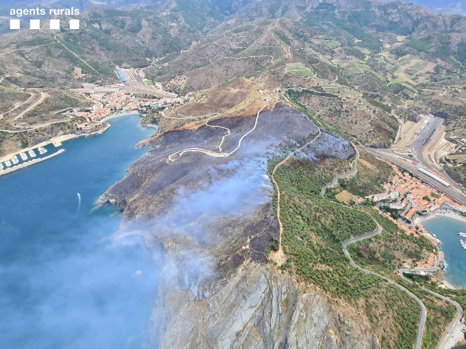
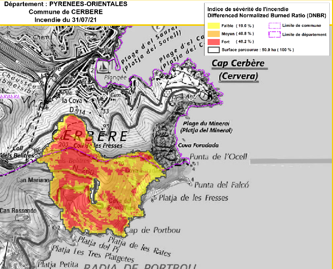
An initial assesment was conducted by ONF RTM on the the impact of fires on forest vegetation and its consequences on erosion and torrential hazard, then carried out an initial feedback on the impact of the Monze fire (Aude department) on 14 August 2019. In a second phase, instrumentation was installed on several key sites in the municipality of Cerbère (Pyrénées Orientales department), which suffered the passage of a 50 ha fire on 31 July 2021.
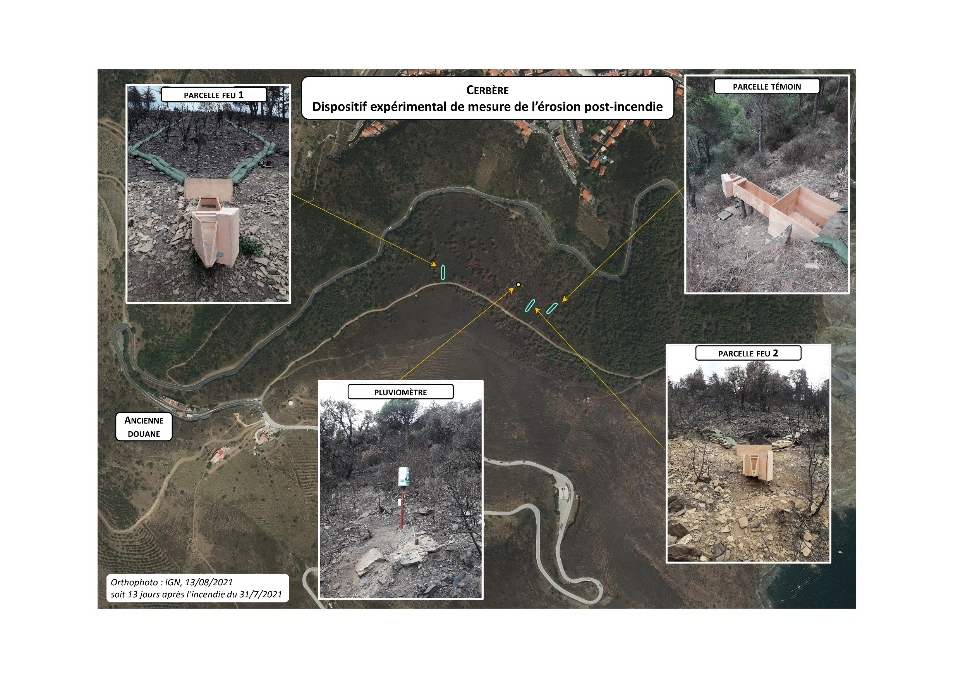
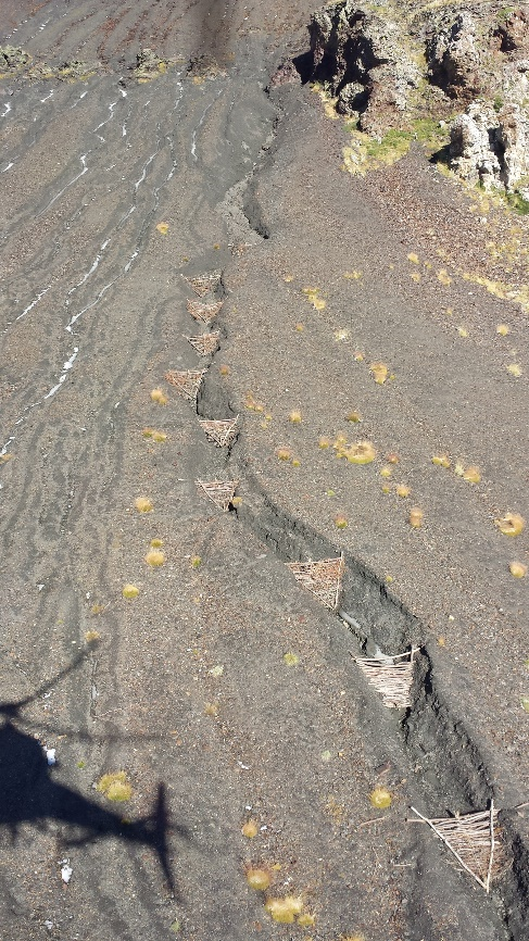
To better understand the mechanisms of soil water erosion, ONF RTM installed three expermiental plots in septembre 2021. The instaled instrumentation allowed the monitoring of rainfalls events during an hydrological season, measurements of rainfall, flow rate, watter height and sedmient quantities were taken. Thanks to the actions carried out in this pilot case (bibliographoc phase, the Monze fire feedback study and the instrumentation of the brurned plots in Cerbère), ONF RTM has further deepened the definition of the guidelines necessary to improve the mitigation of the torrentieal risk induced by the occurrences of forest fires.
Since the end of the twentieth century and the acquisition by the French State, several strategies aiming at decreasing the frequency and intensity of numerous phenomena (torrential flooding, erosion and gullying, landslides) have been carried out on the Baillmarsane watershed (Escaro, Pyrénées-Orientales - France). The objectives are several: to slow down the torrential dynamics and the incision of the longitudinal profile, to drain the surface waters, to fight against the erosion of the slopes.
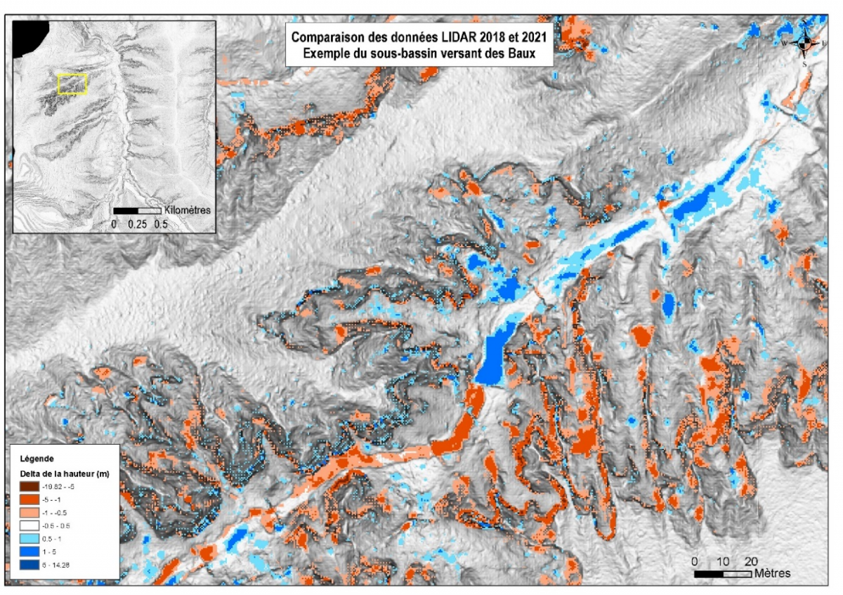
The use and comparison of LIDAR data allows the quantification of erosion phenomena. This quantitative information is all the more interesting to put into perspective following an intense rainfall event.
 |
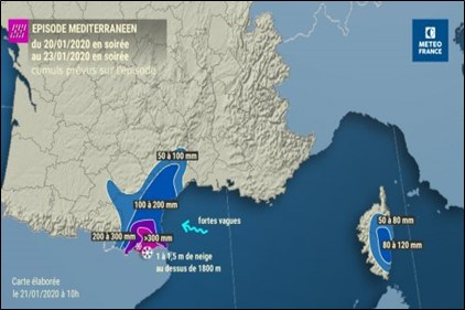 |
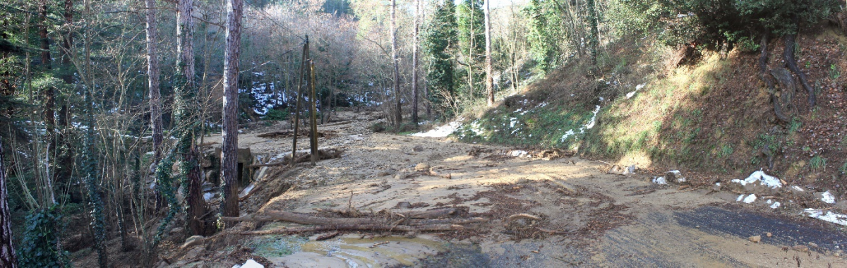
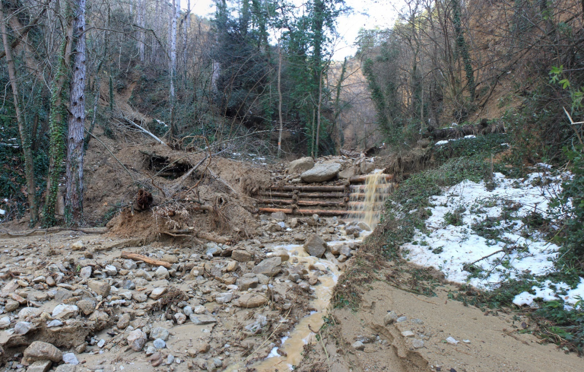
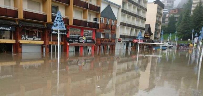
The production of solid materials and the protection of soils against erosion is all the more questioned in the face of major meteorological events. These questions were raised during the Mediterranean episode GLORIA. This rainy-snowy episode, which was active between January 20 and 23, 2020, followed the overflow of the GLORIA storm to the South of France, which impacted the West of the Mediterranean basin. The equivalent of 4 to 5 months of rain fell in 72 hours. These high accumulations generated exceptional floods in the department.
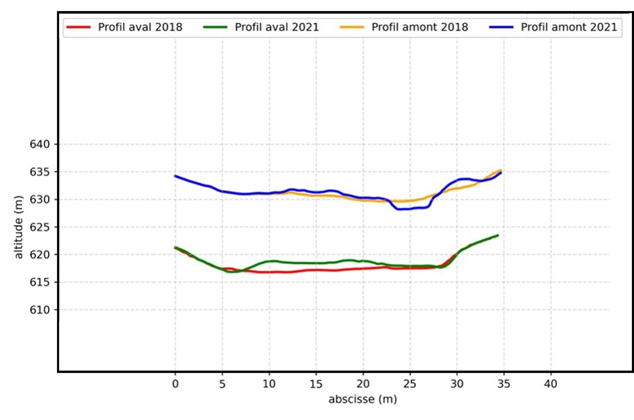
The use of LIDAR data makes it possible to estimate the quantification and spatial analysis of the erosion phenomenon. Through a series of treatments, it will be possible to identify erosion and accretion areas as well as volume ranges allowing direct links between these areas.
Two LIDAR campaigns were carried out by the same provider: one in 2018 and the other in 2021 following the Mediterranean episode.
First, visual comparisons could be made from orthophotographs and shadows made on both dates. The before and after pictures show areas of bank top recession or a landslide niche. The quantification of the soil erosion phenomenon and the accumulation of materials constitutes a second axis of work. It is possible to process data at several scales, from the watershed to a very targeted area of a few m², in order to quantify the volumes of erosion and accretion. This type of processing is all the more interesting when the land is prone to erosion following intense rainfall events. Comparisons of longitudinal and cross-sectional profiles at various time steps will allow to highlight, in a very localized way, the sectors of bank recession or even the heightening of a torrent bed.
 |
 |
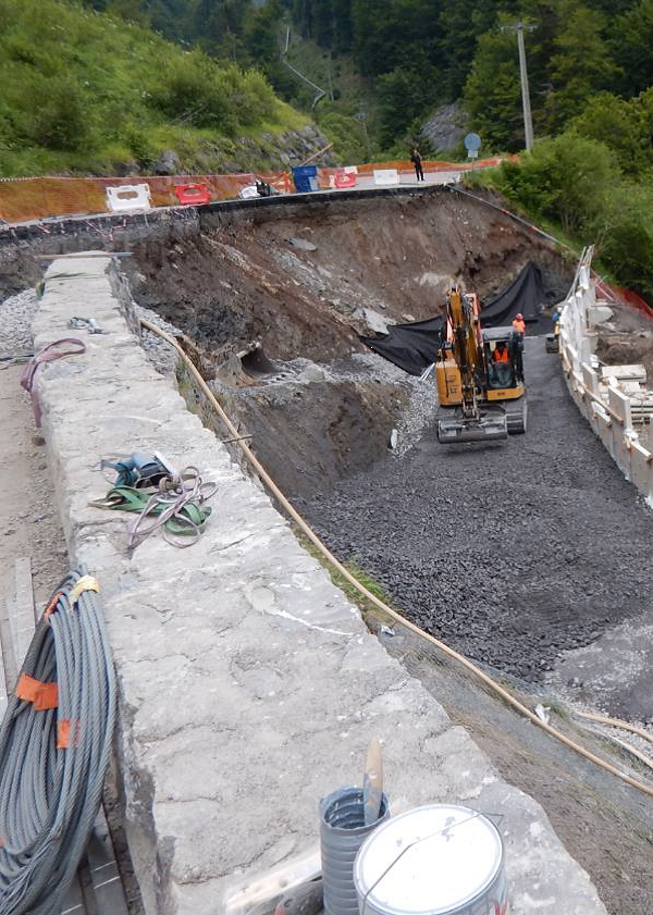
| 2013 – Protection structure in good condition | 2021 – Filled channel and destroyed protection structure |
One of the key actions of the SUDOE MONTCLIMA project is the design and implementation (testing and development) of common Action Plans for prevention and management of natural hazards, which will be validated and/or improved through pilot trials.
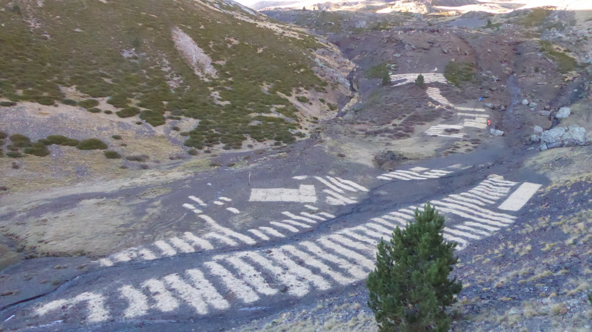
One of these pilot trials, led by FORESPIR and AR+I, is being carried out in the parish of Escaldes-Engordany in the Calm de Claror area situated at 2500 meters a.s.l. where on July 21, 2015, a big storm caused severe erosion in the terregalls (small stone and earth screeds) of the area and, consequently, a significant disturbance of the Claror river (a tributary of the Madriu river) which made the waters of the parish of Escaldes-Engordany (15,000 inhabitants) unfit for human consumption for several days. Once the area has been weakened, subsequent low-intensity rainfall (> 15 mm) ends up generating episodes of exceptional turbidity, which cause new cuts in the supply of drinking water.
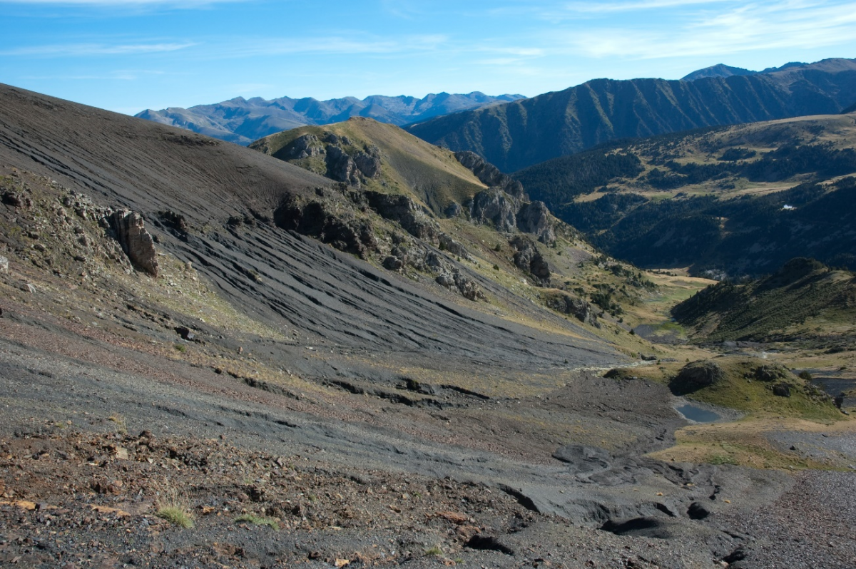
Once the source of the problem has been identified, those responsible are aware of the need to consolidate the sediments and slow down the erosive process with the aim of reducing drinking water supply cuts in an area with very steep slopes and little vegetation. Then, the objective of the control of erosion and turbidity in surface water in the upper part of the Claror stream basin head (Andorra) was realized through the application of nature based solutions with the clear objective of prioritizing respect for the natural environment of this World Heritage Cultural Landscape (UNESCO) protected area. It is for these reasons that, for erosion control work in the Claror basin, we have focused on the use of landscape bioengineering techniques. The main biotechniques of environmental restoration applied were:
1) Sheep remediation works:
1.1) Regularization of bogs and carcaves by slapping with a flock of sheep.
1.2) Fertilization of the areas to be sown due to crowding of the herd,
2) Sowing in 1m bands of eroded areas with Festuca eskia,
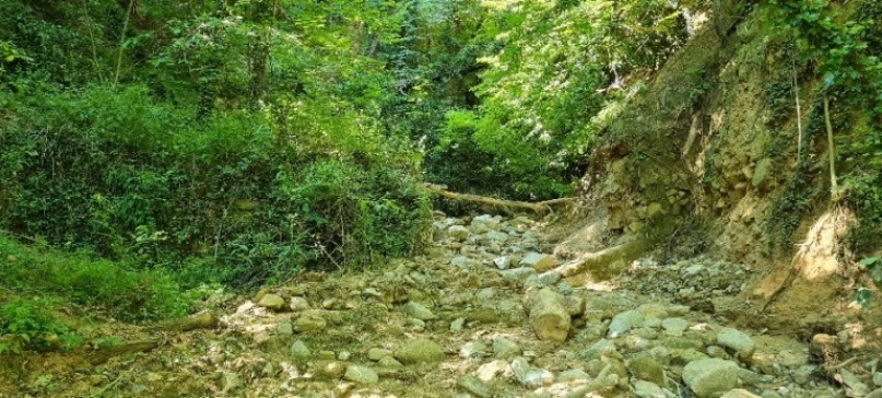
3) Construction of micro dikes of ramage for the retention of flow debris in the sorghum at the head of the basin.
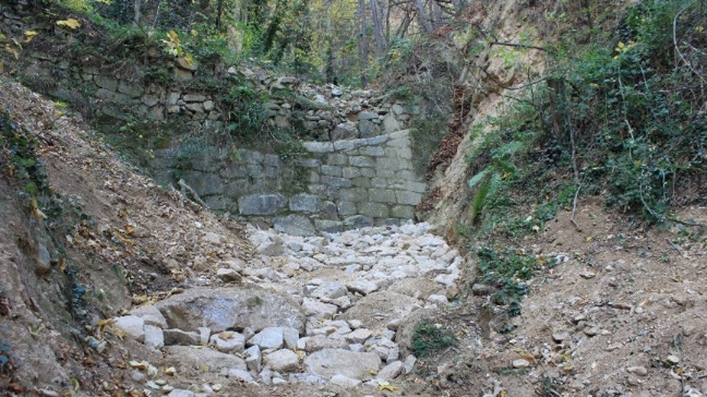
4) Construction of fine retention dam.
5) Restoration of the banks of the Claror river.
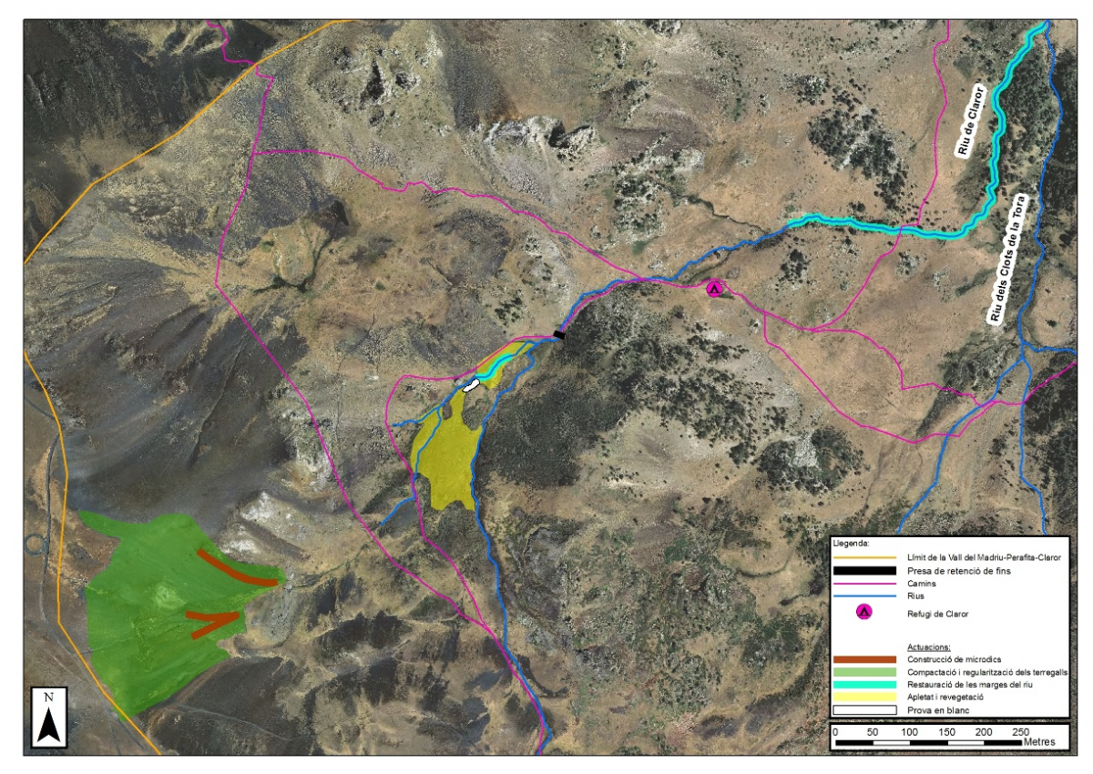
Map of the location of the different works carried out since 2015.
Micro dikes of ramage for the retention of flow debris.
The realization of an experimental trial in 2015 through autumn sowing of Festuca eskia, with one plot fertilized with sheep manure and the other without, allowed the technique to be validated and adjusted to be applied on a large scale in 2016, which has also worked very well. The revegetation of the bare soil aims to stabilize the sediments and the eroded material of recent surface exposure. The revegetation began with a single species, the grass (Festuca eskia), since it is the most predominant plant in the pastures around the area to be stabilized, and practically the only one that colonizes with high coverage the poorest soils and with more slope (observed in staggered configuration on slopes of up to 34°). In addition, it is a rustic plant, little appreciated by livestock, with predominant vegetative reproduction and very well adapted to the rigors of the high mountain climate. In fact, it is a Pyrenean endemism. Through the establishment of a grass cover, it is intended to provide protection against the direct impact of raindrops on the ground (splash erosion), and also because of the increased cohesion in the ground provided by the roots and the organic matter, this without underestimating the increase in hydraulic roughness provided by the leaves and the stems of the plants that, acting as a filter, limit laminar erosion. The erodibility of a bare soil is estimated to be about 250 to 400 times (factor C of the universal soil loss equation according to criteria universal soil loss equation) higher than the same soil completely covered (>95%) with herbs, ceteris paribus. The spectacularity of these figures makes it vital to quickly revegetate barren areas in order to control water pollution.
Then, in pilot trials of the MONTCLIMA project the objective was to strengthen and amplify the vegetated surface. Considering the lack of commercial seed of this species, lawn seeds were collected manually in August 2021. The sowing was done manually in the month of May 2022 and in order to cover more surface, sowing strips of one meter width were made every two meters (sown meter - barren meter), and the seeds were covered with protective layer (mulch) of straw to protect them from water and wind erosion, from the cold during germination and, above all, from drying out the soil during summer droughts.
The application of sheep manure increased biomass production by 8 times. The torrential lava containment micro-dykes have worked properly. Erosion control has been very satisfactory, since the outbreak in 2017, with no new drinking water cuts. The sheep remediation works applied in the corrective measures in the basin of Claror river have given very satisfactory results, in harmony with the environment, and demonstrate the potential of integrating pastoral activity to achieve synergies with the environmental quality needs that today's society requires.
With the various environmental restoration works, some of them pioneers in the role of stabilizing land damaged by intense erosive processes, carried out in the area affected by the torrent, it is expected that three to five years of follow-up will be necessary post-sowing, continuing with the application of corrective measures, to complete and maintain the micro-dykes and, above all, to fix the vegetation to the point that the vegetation cover can be considered successful and, consequently, controlled erosion in the levels before the torrent, or even lower. These works will greatly accelerate the fixation of a large part of the finer sediments that cause great turbidity in the water of the Claror river and will minimize the risk of cuts in the water supply to the town of Escaldes-Engordany.
Finally, it should be noted that the results of this restoration will be of great use if, in the future, protocols or contrasted strategies are to be developed to control soils damaged by intense erosive phenomena that will undoubtedly, sooner or later, affect us again.
One of the key actions of the SUDOE MONTCLIMA project is the design and implementation (testing and development) of common Action Plans for prevention and management of natural hazards, which will be validated and/or improved through pilot trials.
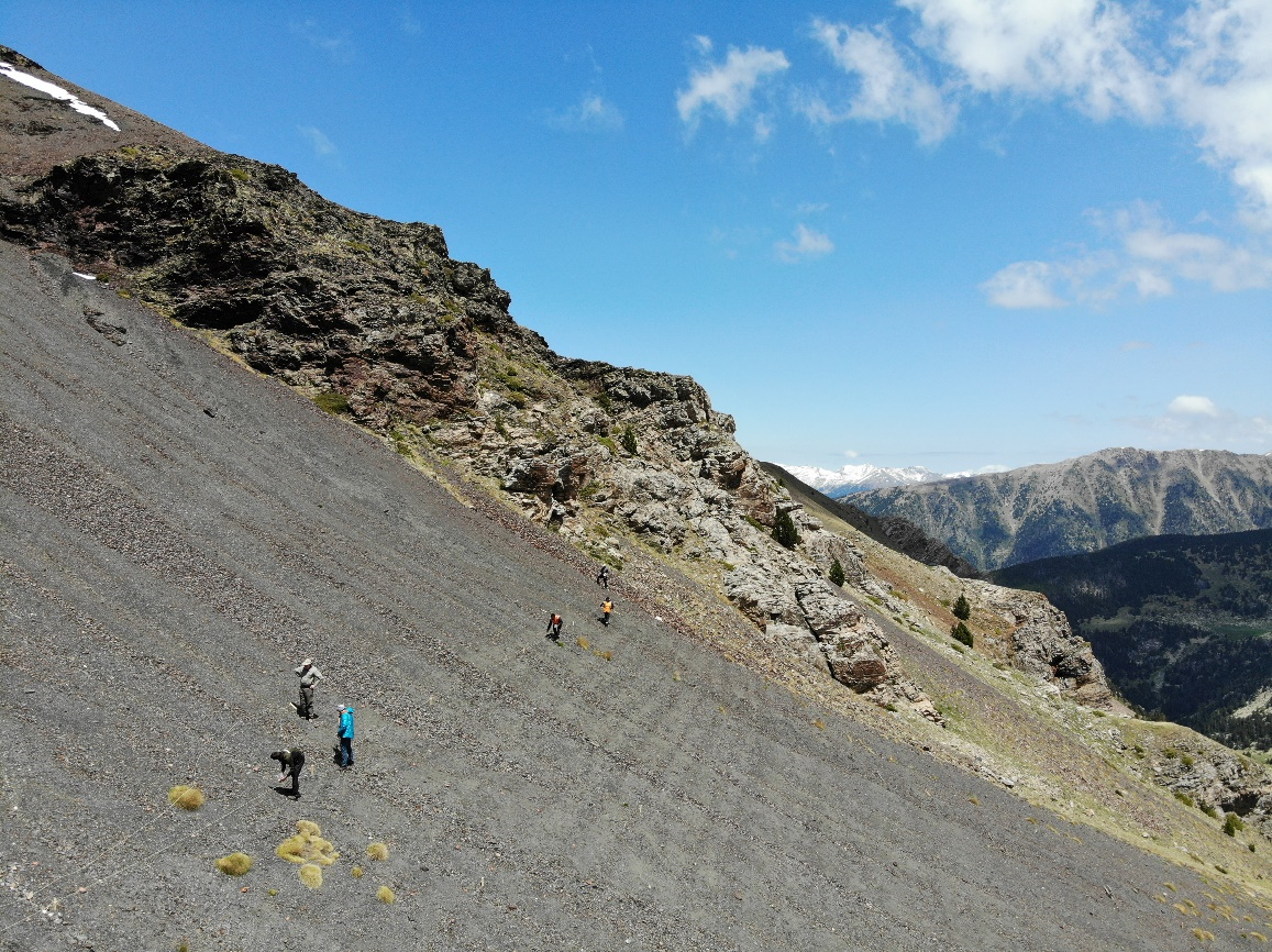
One of these pilot trials, led by FORESPIR and AR+I, is being carried out in a Calcareous mountain scots pine (Pinus sylvestris) forest (Andorra la Vella, Principality of Andorra) the main objective to plan and implement an adaptive forest management action in a protection forest of blocks and rocks, vulnerable to high intensity fires in Andorra. It will also serve as a pilot and demonstration forest of good practices in preventive forestry, to improve the knowledge of these forest structures against the foreseeable impacts of fire risk, and to allow forest managers in the Pyrenees to apply techniques that promote the increase of the resilience of protective forests.
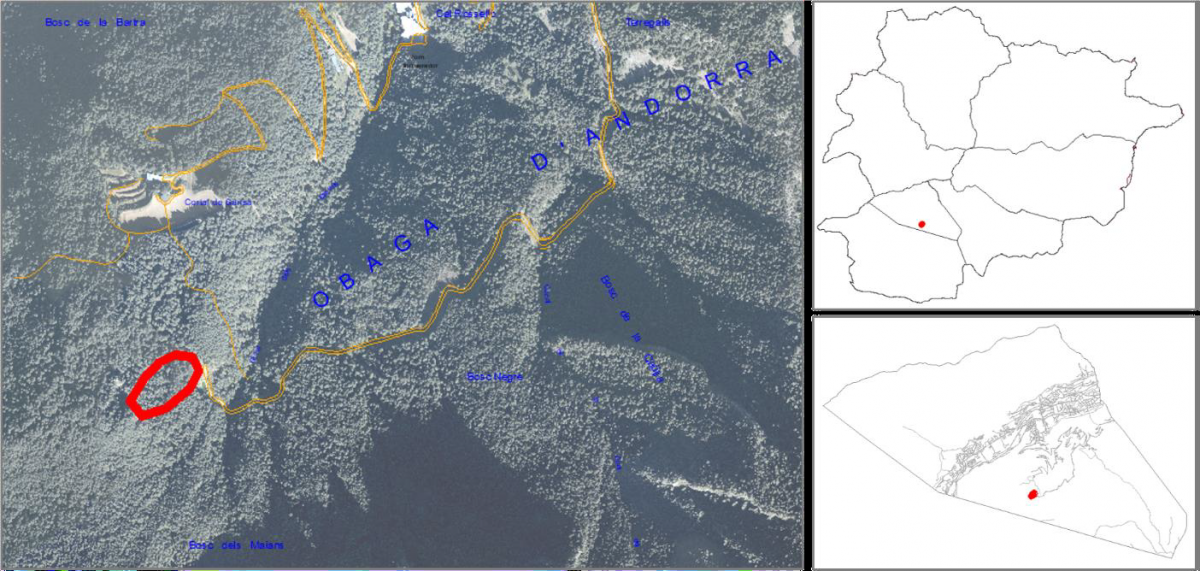
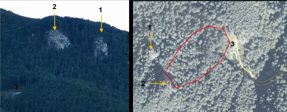
The pilot trial has been carried out at the "Bosc del Maians" forest, located on the northern slope of the parish of Andorra la Vella and covers an area close to 100 ha. The stand, which is entirely on public ownership, starts at the foot of the rocky cliff (number 2, photo 2 and 3) close to the viewpoint "del roc de la Palomera" (number 1, photo 2 and 3) and runs in the direction of the slope until it reaches the picnic area and the site of the water collection infrastructure and artificial hydrant for the defence and fight against forest fires (number 3, photo 2 and 3) at the end of the "Maians" forest track.
For the delimitation of the site and morphology of the 1ha stand, the "risk-exposure unit" method proposed by the French National Forestry Office was used together with an analysis of the slopes and orientation of the slope.
To assess the degree of protection of vegetation against boulder and rock mobilisation, the Hazard Monitoring Index (HMI) was estimated. The HMI takes into consideration the possible impacts of climate change on the forest stand, the current stand characteristics, its resilience, and its natural dynamics. However, it does not incorporate the effects or interaction of other disturbances that could cause a significant alteration in the functioning of the stand, such as the consequences of a forest fire. For the estimation of the HMI, a forest inventory of the study area was carried out in order to characterise the main variables required and a value of 3 was obtained, which corresponds to a medium protection effectiveness of the vegetation against rockfall.
Vulnerability to crown fire is moderate and conforms to the B10 typology defined by Fernandez, et al. (2008). In order to minimise the vulnerability of the forest to crown fires, a series of silvicultural treatments have been implemented to transform the B10 forest typology to a C6 forest typology. The C typologies are characterised by a vertical discontinuity between the strata, a situation that prevents the transfer between surface and ladder fuels with the tree canopy.
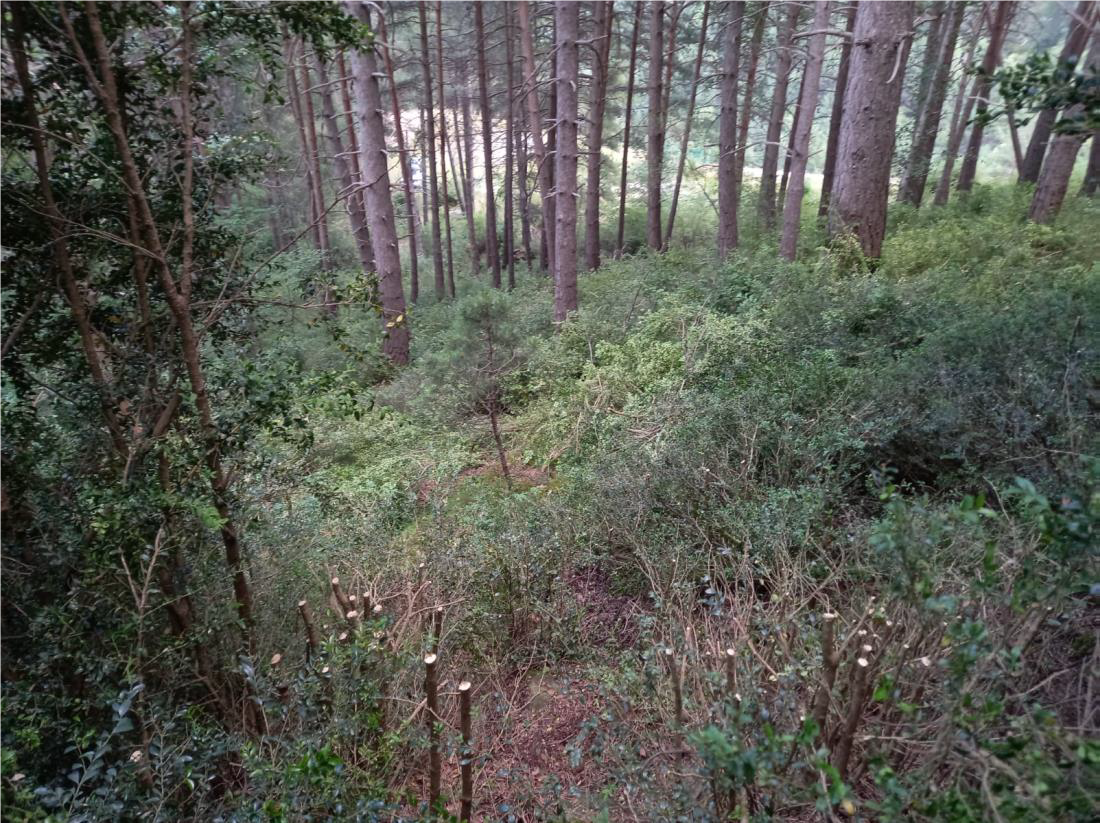
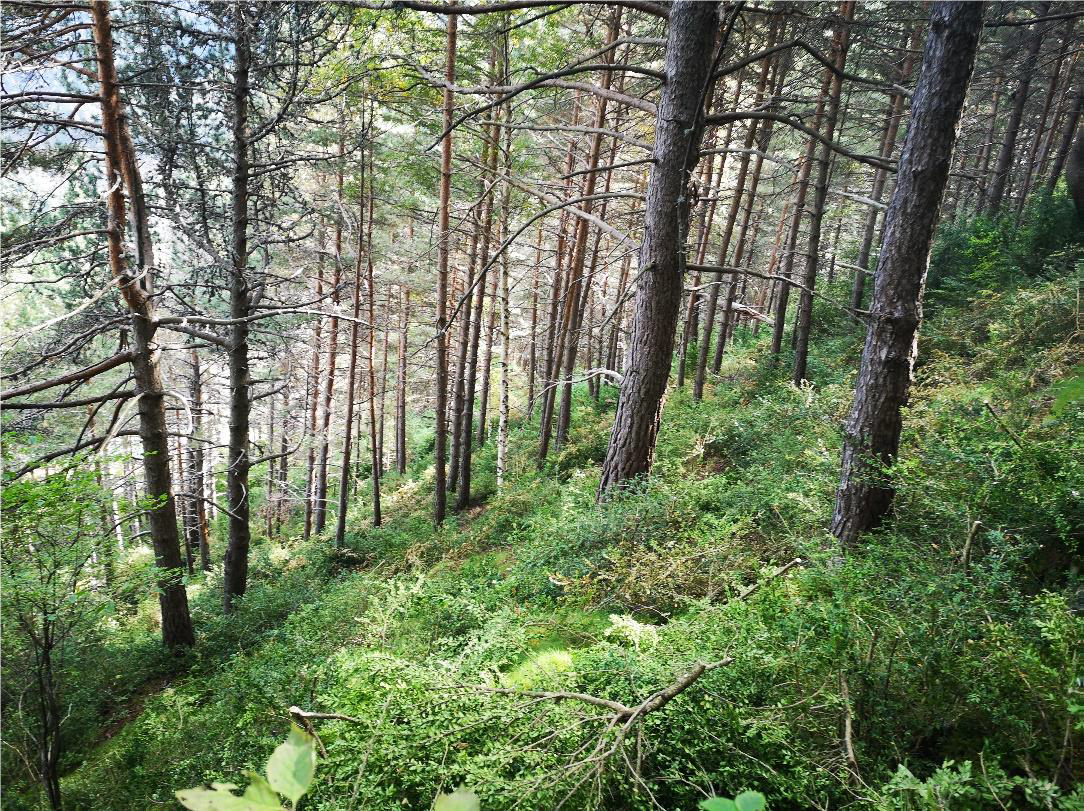
Then, an action was planned and carried out to minimise the risk of fire, in the short and medium term, by reducing the capacity of fire to spread at high intensity, especially its capacity to affect the tree canopy, without affecting the capacity or degree of protection of the forest structure against falling rocks. This reduces forest mortality and consequently ensures the continuity of the protective function.
Silvicultural treatments have mainly focused on the shrub layer and the lower branches of the trees, these two components being the main drivers of fire propagation between the ground and the tree canopy (ladder fuel or vertical transfer). On the one hand, selective clearing and generalised pruning was carried out over an area of approximately 1 ha. Likewise, selective thinning has been carried out to favour the growth of the hardwood species on the site, and the scrub around the smaller trees or regenerated conifers has been cleared to maximise their survival and future viability. At the same time, the surroundings of the few broadleaved trees present have been cleared, so that they can grow and gain relative importance within the stand, given that mixed structures are of great interest to improve the degree of protection.
 |
 |
The simulation of the fire behaviour, using BehavePlus 6 software, generates results that point in the same direction as the above. In this sense, the results of the simulation of the initial scenario show that despite not generating active crown fires, the structure, and above all the ladder fuels, can promote the appearance of crown and torch activity, which together with the height of undergrowth, means an average probability of mortality of the tree layer of 100%.
A different situation is observed in the post-treatment scenario, assuming that the remains of the treatments have already been partially mineralised, and a surface fuel pattern dominated by low to medium height scrub is assumed. Under these conditions, crown activity disappears, with most of the fire being surface fires, and the height of undergrowth decreases drastically with respect to the initial scenario, going from 14m to 2m, so that the estimated average mortality is around 58% of the trees.
With the results at hand, it can be expected that the treatments have significantly reduced the vulnerability of the protective forest to high intensity forest fires.
Soil is a finite and non-renewable natural resource that provides a variety of ecosystem or environmental services. Not only is it the natural basis for the production of food and raw materials on which the world's society depends, but it is also host to a quarter of our planet's biodiversity. However, soil degradation is one of the greatest threats of the 21st century. According to literature studies, soil degradation processes have already affected 33% of the earth's surface, leading to a significant reduction in soil quality and functionality. Among the soil degradation processes, water and wind erosion are among the most important. The European Environment Agency estimates that 115 million hectares are exposed to water erosion processes (12% of the European land area) and 45 million hectares to wind erosion. It is estimated that between 8 and 12 million hectares of fertile soil are lost annually in Europe, resulting in an economic loss of approximately EUR 1.25 billion.
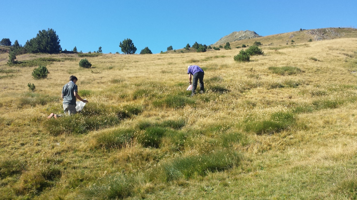
Within the framework of the MONTCLIMA project, a study of soil erosion is being carried out in a vineyard in Rioja Alavesa with a high risk of erosion due to its topography, but which in turn represents the general situation of vineyards in Rioja Alavesa, since most of them are located in areas with steep slopes. It is essential to find measures to reduce soil erosion in vineyards since, as a result of climate change, this risk is expected to worsen due to changes in the distribution of rainfall.
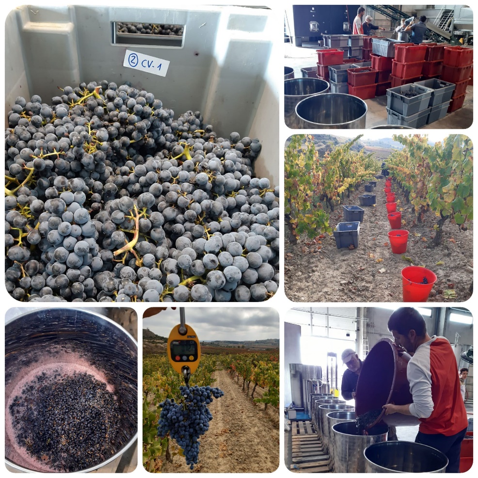
The trial that began in 2019 with the MONTCLIMA project is being carried out on a plot of Graciano grapes located in the municipality of Elvillar (Álava), with slopes of 10-20%, managed in organic farming and belonging to the Maisulan winery. It consists of three treatments:
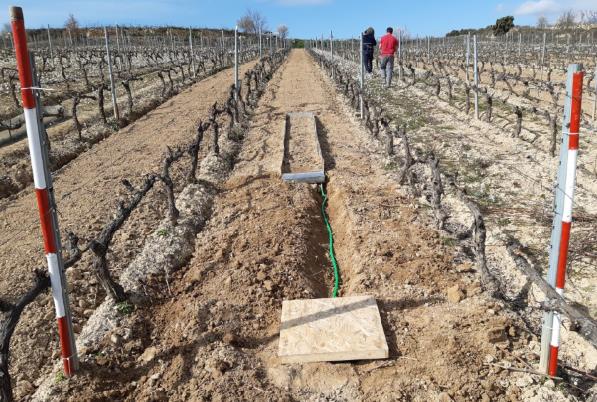
Sampling of erosion is carried out in the erosion traps installed in the field (Gerlach Boxes), both of the soil and of the amount of water and solutes collected by runoff. In order to study the effect of the three treatments, each of the vines that makes up the elementary plots (13 vines per repetition) are harvested separately and grape samples are taken to analyse their quality.
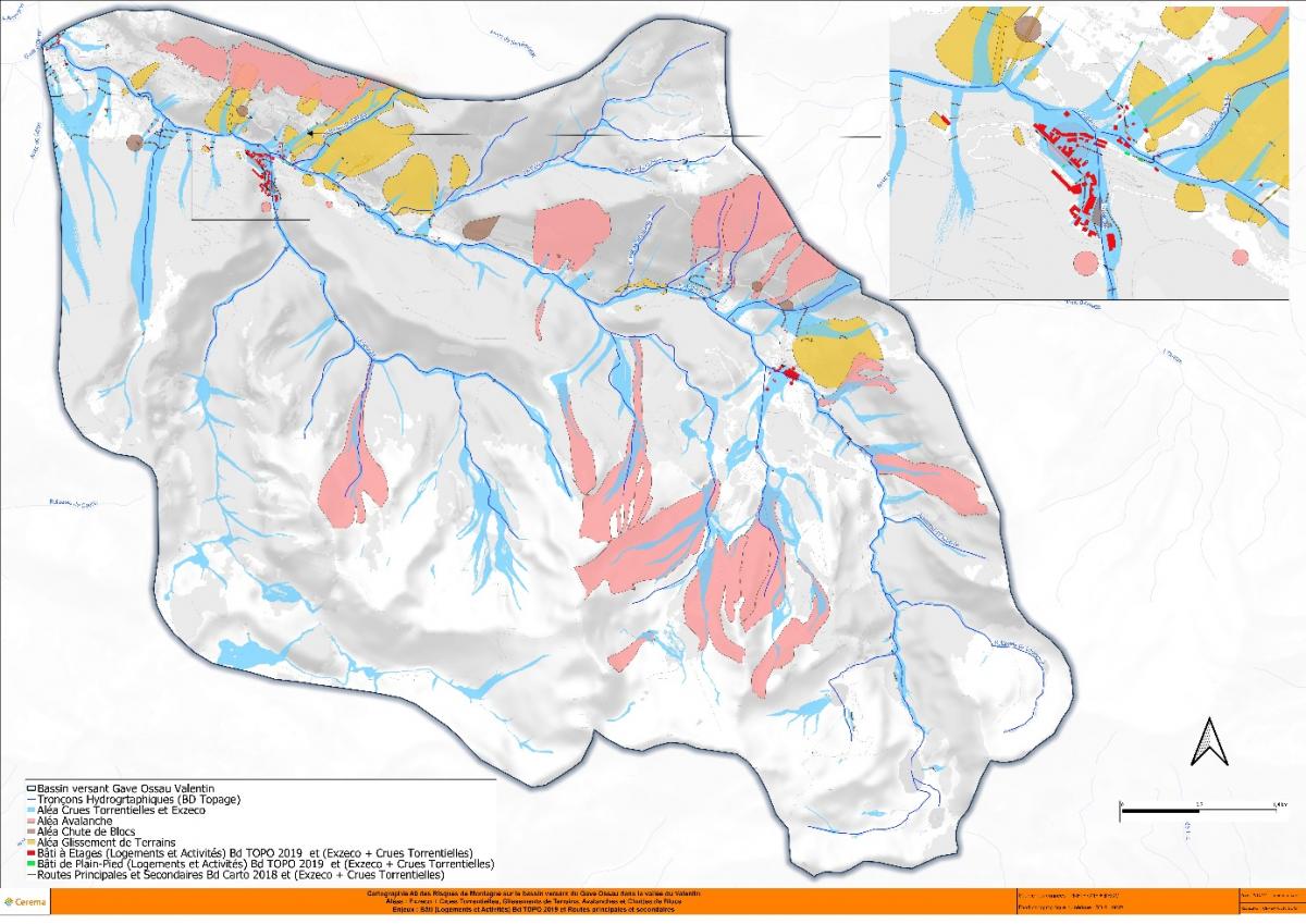
Implementation of a participatory and co-constructed approach to territorial resilience to natural hazards in the Valentin valley, commune of Eaux-Bonnes, to better integrate the challenges of adaptation to the consequences of climate change.
The valley of Valentin on the commune of Eaux-Bonnes (64) presents many stakes concentrated on a restricted linear:
- The biggest ski resort of the Pyrénées - Atlantiques (Gourette)
- Three or four campings close to the river or at risk of flooding,
- The Rd 918 access to the resort in winter and to the Aubisque pass in summer
- The hydroelectric production.
- Thermal baths at Les Eaux Bonnes
This valley is subject to many risks and environmental constraints that leave limited opportunities for sustainable development.
 |
 |
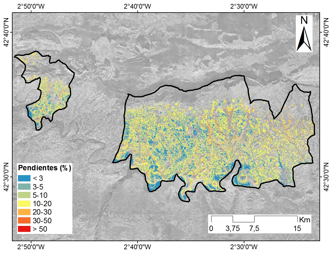
The knowledge of these risks in the current context is globally well identified and has been the subject of additional inventories by ONF-RTM in the framework of Montclima: 680 events recorded since 1800, including 604 avalanches, 11 block falls, 33 landslides / mudflows and 32 torrential events.
In addition to the updated inventory of these 4 hazards, Cerema has calculated the potential envelope of the runoff hazard on the basis of a 5 m DTM of the IGN with the Exzeco method.
An analysis of the stakes impacted (BD TOPO 2019) in the study area by these envelopes of torrential floods (ONF-RTM) and potential envelope of runoff hazard (Cerema - Exzeco) shows the stakes impacted or contained in these envelopes:
37 single-storey buildings out of 157 (23.5%), 104 multi-storey buildings (housing and activities) out of 332 (31.3%), 43 engineering structures out of 80 (53.7%), 5,303 kms of main and secondary roads out of 80,330 kms (6.6%) and finally 69 jobs and activities (BD Sirene 2021) out of 261 (26.4%)
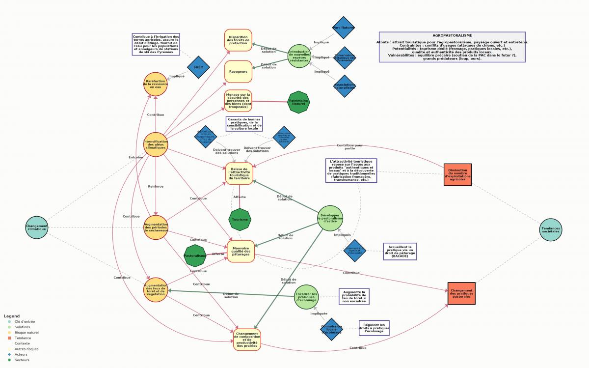
The challenge and interest of the risk resilience approach undertaken in this territory is :
- While updating locally the past knowledge on hazards, to integrate as well as possible the uncertainties and trends calculated on the scale of the Pyrenean massif (scientists) on the effects of climate change in terms of intensity or frequency by considering these trends as acquired within the framework of this territorial approach, which postpones in part the reflections / debates and energies on "how to adapt and become more resilient".
- To avoid exclusively technical and/or expert approaches and to engage in a reflection with the actors of the territory through a co-constructed diagnosis, fed by their field visions and reflections or knowledge of other territories.
- To engage a systemic approach, which establishes links between issues and actors, loops, networks and chains of impacts at several levels.
- To question the long term (30 - 50 years) and to move towards an operational action plan that will guide the adaptation of the territory towards more resilience.
 Resilience Compass - Framework for Thinking
One of the key actions of the SUDOE MONTCLIMA project is the design and implementation (testing and development) of common Action Plans for prevention and management of natural hazards, which will be validated and/or improved through pilot trials.
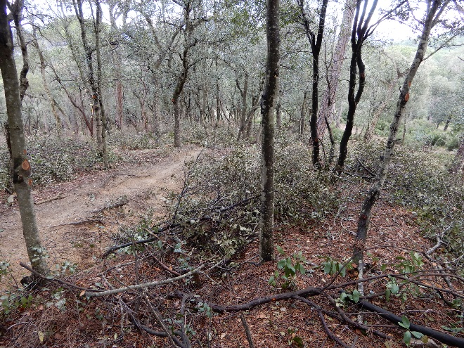
One of these pilot trials, led by CREAF, is being carried out in a Mediterranean oak forest in the Montnegre-Corridor Natural Park (Barcelona, Catalonia, Spain) with the aim of reducing the vulnerability of the forest to the fire risk. The pilot trial consists of applying adaptive forest management in a Strategic Management Point (PEG) for the control of large forest fires. The PEGs are locations in the territory where the modification of the fuel and / or the preparation of infrastructures allow the extinguishing service to carry out safe attack manoeuvres that reduce the progress of a large forest fire. In this sense, they represent spaces that, due to their spatially strategic location, have a key role as protective effect on a relevant surface of the Natural Park.
The pilot trial has been carried out at the Can Bordoi estate, in the municipality of Llinars del Vallès (Barcelona), which covers an area of 214 ha. Within this estate, the trial is performed in the extreme southwest, since in the case of a large forest fire that comes from the west and which would be the most likely in the area, it could lower the intensity of the fire, facilitating the tasks of extinguishing firefighters and preventing the entire massif from burning. Moreover, the applied management helps to strengthen the forest mass to the risk of drought affectation.
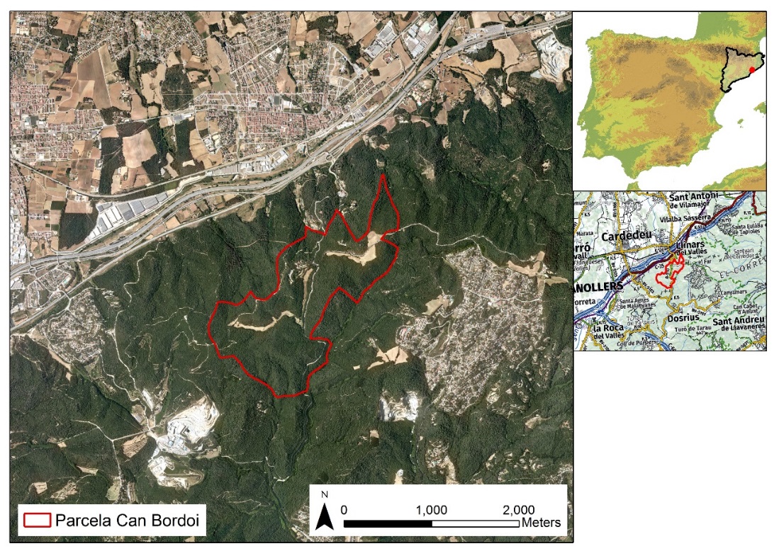
Location of the Can Bordoi estate, in the municipality of Llinars de Vallès, North of Barcelona.
The pilot trial has consisted of the application of adaptive forest management (selective felling, where the largest holm oaks are left, and scrubland clearing) on a 5.4-hectare plot and of creating open woodlands (elimination of stone pines affected by Tomicus and pasture recovery) on a 4.7 ha plot to create an open area that helps improve the fire resistance of the massif. In addition, a control plot of 1.9 ha has been left where no action will be taken and which will serve to compare with the managed area. The action has been carried out between February and June 2020 by the Montnegre-Corredor Forest Owners Association.
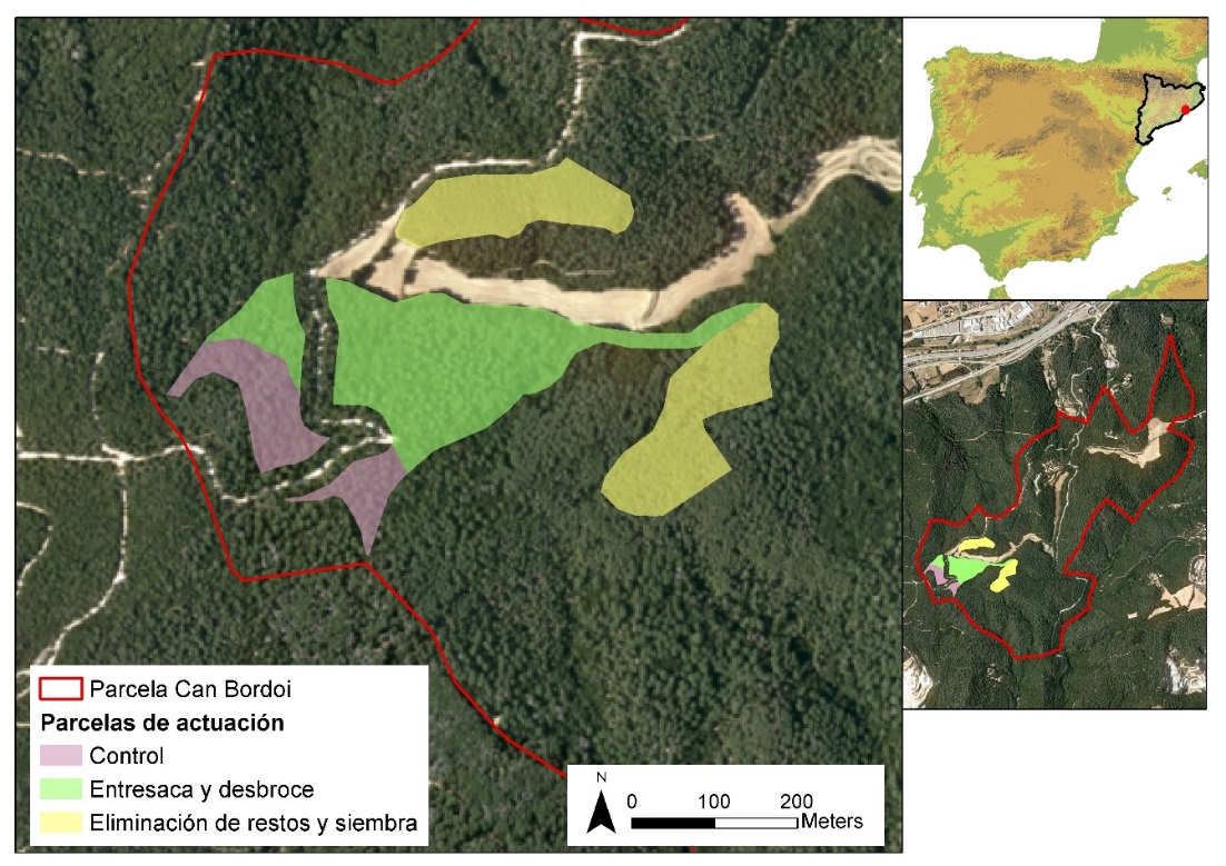
Delimitation of the action plots within the Can Bordoi estate.
The characterisation of the actuation and the annual monitoring is based in the installation of eight permanent inventory plots (10 m circular plots), five in the managed area and three in the control area. In these plots, a pre-action inventory was performed between January and February 2020 to characterize the forest stand before the management. Later on, a post-action inventory was implemented in June 2020 to estimate the weight of the intervention (volume and basimetric area extracted, changes in fuel continuity ...). Finally, a monitoring network was installed in July 2020 to monitor and measure the forest and environmental variables during two years (2020-2021). This campaign consists of recording the evolution over time of a series of indicators that allow to know if the Holm oak forest is less vulnerable to the risk of fire thanks to the applied adaptive forest management. To do this, these indicators are monitored in the area where management has been applied and in the control plot, and compared. The monitoring indicators are the following: changes in forest structure, fuel continuity, fuel moisture, forest health, soil moisture, temperature and relative humidity.
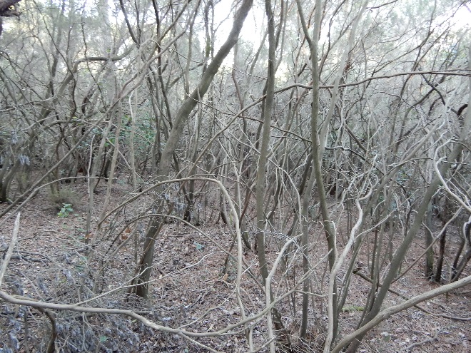
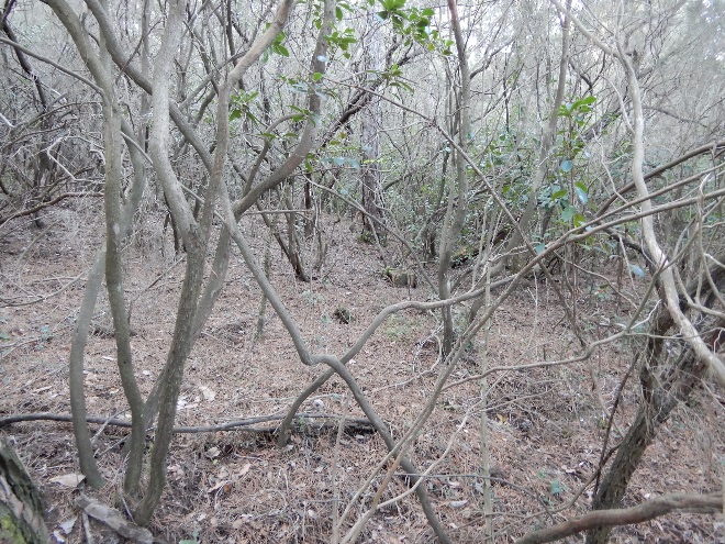
Initial state of the oak forest of Can Bordoi.
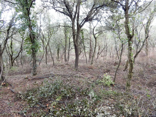
Final state of the oak forest of Can Bordoi after the application of adaptive forest management